|
|
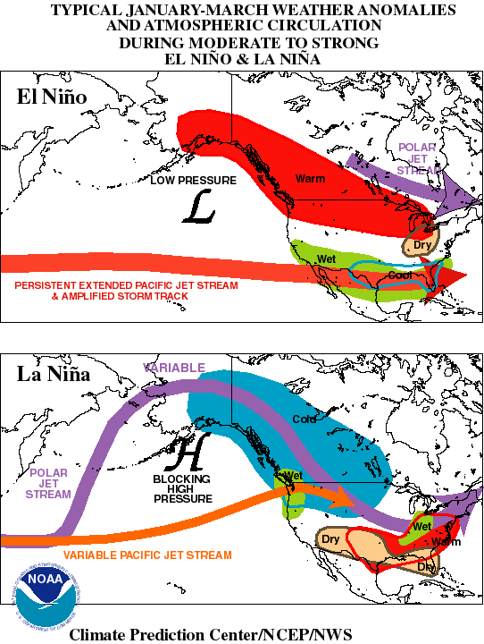
General: During winter El Niño episodes (top map)
feature a strong jet stream and storm track across the southern part of
the United States, and less storminess and milder-than-average
conditions across the North. La Niña episodes (bottom map) feature a
very wave-like jet stream flow over the United States and Canada, with
colder and stormier than average conditions across the North, and warmer
and less stormy conditions across the South. |
| |
|
Detailed El Nino: El Niño episodes are associated
with four prominent changes in the wintertime atmospheric flow across
the eastern North Pacific and North America. The first is an eastward
extension and equatorward shift of the East Asian jet stream from the
International Date Line to the southwestern United States. The second is
a more west-to-east flow of jet stream winds than normal across the
United States. The third is a southward shift of the storm track from
the northern to the southern part of the United States. The fourth is a
southward and eastward shift of the main region of cyclone formation to
just west of California. This shift results in an exceptionally stormy
winter and increased precipitation across California and the southern
U.S, and less stormy conditions across the northern part of the country.
Also, there is an enhanced flow of marine air into western North
America, along with a reduced northerly flow of cold air from Canada to
the United States. These conditions result in a milder than normal
winter across the northern states and western Canada. |
| |
|
Detailed La Nina: La Niña episodes are associated
with three prominent changes in the wintertime atmospheric flow across
the eastern North Pacific and North America. The first is an
amplification of the climatological mean wave pattern and increased
meridional flow across the continent and the eastern North Pacific. The
second is increased blocking activity over the high latitudes of the
eastern North Pacific. The third is a highly variable strength of the
jet stream over the eastern North Pacific, with the mean jet position
entering North America in the northwestern United States/ southwestern
Canada. Accompanying these conditions, large portions of central North
America experience increased storminess, increased precipitation, and an
increased frequency of significant cold-air outbreaks, while the
southern states experiences less storminess and precipitation. Also,
there tend to be considerable month-to-month variations in temperature,
rainfall and storminess across central North America during the winter
and spring seasons, in response to the more variable atmospheric
circulation throughout the period |
Information gathered from NOAA at:
http://www.cpc.noaa.gov/ |