Groundwater Storage Losses Substantial Across Eight State Aquifer System
December 5, 2011
More than 280 million acre-feet of groundwater has been withdrawn from the Mississippi embayment aquifer system between 1870-2007, according to a new water modeling tool developed by the U.S. Geological Survey.
This cumulative withdrawal, which is the equivalent of five feet of water over 78,000 square miles, contributes to one of the largest losses of groundwater storage anywhere in the United States.
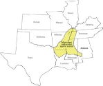
The new USGS modeling tool was designed to help resource managers find a balance between water supply and demand for future economic and environmental uses. The three-dimensional model provides a holistic picture of how water flows below ground and how it relates to surface-water. The Mississippi embayment aquifer system encompasses approximately 78,000 square miles in Alabama, Arkansas, Illinois, Kentucky, Louisiana, Mississippi, Missouri and Tennessee. A report documenting past and current groundwater conditions, and tools to forecast regional response to human use, climate variability, and land-use changes are all available online.
"Our groundwater aquifers are nature's own natural method for storing water safely long term where it is less vulnerable to loss through evaporation and surface contamination," explained USGS director Marcia McNutt. "We should be as concerned about loss of groundwater as we are about dropping levels in reservoirs behind dams, because in the depths of the worst drought, when the rivers run dry, it is only the groundwater that will sustain us."
"This model can assist water resource managers faced with increasing management challenges and constraints," said USGS hydrologist, Brian Clark. "This model could be used to evaluate regional issues, such as streamflow declines from groundwater pumping or conservation scenarios to lessen water level declines."
The Mississippi embayment aquifer system includes one of the nation's most productive agricultural regions, with an annual value of $3 billion per year. Two of the region's most important aquifers lie beneath the Mississippi embayment. The pumping from the Mississippi River Valley alluvial aquifer accounts for more than 12 percent of all groundwater pumped in the United States.
"This model will help officials find ways to better manage the area's present and future groundwater resources," said USGS Arkansas Water Science Center Director, Dave Freiwald. "This is the most recent large-scale, comprehensive assessment of groundwater resources in the area."
This report is a product of a four-year study being funded by the USGS Groundwater Resources Program. Information derived from this and future studies of more than 30 regional aquifers will provide a collective assessment of America's groundwater availability.
To develop the model, scientists examined more than 2,600 geophysical logs, some dating back to the early 1960's. Researchers examined groundwater and surface-water data from the early 1900's to 2007, groundwater withdrawal information, and thousands of miles of surface-water bodies to illustrate how the water system works and how supplies have changed.
A comprehensive report detailing the research, "Groundwater Availability of the Mississippi Embayment," and a factsheet, "A New Tool to Assess Groundwater Resources in the Mississippi Embayment," are available online.
SOURCE: USGS
Copyright © 1996 - 2011, VertMarkets, Inc. All rights reserved. To subscribe or visit go to: http://www.wateronline.com