6.6 Mw - NORTHERN SUMATRA, INDONESIA
| Magnitude | 6.6 Mw |
| Date-Time |
|
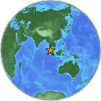
| Location | 2.973N 97.997E |
| Depth | 110 km |
| Distances |
|
| Location Uncertainty | Horizontal: 13.6 km; Vertical 8.3 km |
| Parameters | Nph = 249; Dmin = 108.0 km; Rmss = 1.11 seconds; Gp = 21° M-type = Mw; Version = 6 |
| Event ID | US c0005pdr |
For updates, maps, and technical information, see:
Event Page
or
USGS Earthquake Hazards Program
National Earthquake Information Center
U.S. Geological Survey
http://neic.usgs.gov/