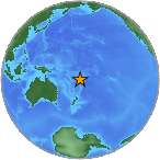
7.2 Mw - FIJI REGION
| Magnitude | 7.2 Mw |
| Date-Time |
|
| Location | 21.596S 179.270W |
| Depth | 593 km |
| Distances |
|
| Location Uncertainty | Horizontal: 17.2 km; Vertical 18.7 km |
| Parameters | Nph = 49; Dmin = 511.0 km; Rmss = 0.85 seconds; Gp = 79° M-type = Mw; Version = 6 |
| Event ID | US c0005vcv |
For updates, maps, and technical information, see:
Event Page
or
USGS Earthquake Hazards Program
National Earthquake Information Center
U.S. Geological Survey
http://neic.usgs.gov/