Experts Drill Arctic Ice To Fathom Speed Of Melt
Date: 08-Sep-11
Country: ARCTIC
Author: Gerard Wynn and Stuart McDill
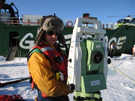
Nick Toberg, part of a team of scientists from Cambridge trying to
find out why Arctic sea ice is melting so fast, conducts survey work
on ice floe 500 miles (800 km) from the North Pole September 3,
2011.
Photo: Reuters/Stuart McDill
As polar bears stalked their ship, scientists drilled into the Arctic sea ice this week to try and figure out why it's disappearing so fast.
The disintegrating ice floes -- each half the size of a football field -- floated among narrow lanes of open water next to the Arctic Sunrise, the Greenpeace ice breaker likely to be the most northerly ship in the world, according to ice pilot Arne Sorensen.
Nearby, in a monochrome landscape between the Norwegian island of Svalbard and the North Pole, a large cub patted and licked a lollipop-shaped part of laser scanner as it passed. Cracks several meters wide appeared in seconds beneath the scientists' feet, prompting a hasty retreat.
Changes in the Arctic are being driven both by manmade greenhouse gases and natural weather patterns. With less ice, less sunlight is reflected back into space, warming the air and melting more ice.
Experts say thinning of ice over recent decades may hasten an ice-free summer as soon as 2020. And, while thickness is more difficult to measure by satellite than area, if anything it is more important.
That has put the onus on better data, through new satellite, plane and submarine observations and a low-tech approach on the ice itself -- drilling holes and poking a tape measure down.
"What the radar of the satellite sees is just the part of the ice that is really above the water and since about nine tenths of the ice is underneath the water there is a huge uncertainty in what the satellite can actually see," said Cambridge University PhD student Till Wagner told Reuters.
"That's what we are here for to get a better handle on how thick the ice actually is," he said, standing on a floe next to the Arctic Sunrise.
WILD CARD
The sea ice area retreats each summer and this year is closing on a record low in 2007. With one week of the melt season to go, it is now less than two-thirds of the area it covered in the early 1970s.
The sea ice, distinct from ice sheets hundreds of meters thick over rock in Greenland, floats on the Arctic Ocean and wildlife including polar bears and walruses depend on it for survival.
Wider "wild card" risks from an ice-free ocean in summer include weather disruption as the difference in temperature between the equator and poles is the engine of the world's weather.
If the Arctic Ocean were open sea in autumn, without an insulating layer of ice, that would allow more warming of the polar air.
One forthcoming study calculated that the total volume of Arctic sea ice fell to a record low in 2010 [ID:nL5E7K52X4], suggesting that thinning has continued despite a rather steadier ice extent over the past three or four years.
Other scientists are poring over new satellite estimates of thickness from the European Space Agency's CryoSat, which will plug a gap in data between the last U.S. ICESat satellite and the start date for the next around 2016.
"The preliminary map of CryoSat thickness shows reasonable agreement ... with airborne data," said University College London's Seymour Laxon by email. "Some of this data is only now becoming available."
On the ice floe near the North Pole this week, the researchers' coup de grace is a three-dimensional scan which may help scientists understand its shape and strength better.
"Traditionally, you might be doing a section or a plan to understand an area but to fully see this in 3D and combine it with the satellite information we are able to really get a really high resolution understanding of what's going on out here," said Will Trossell, at start-up company Scanlab.
(Editing by Karolina Tagaris)
![]()
© Thomson Reuters 2011 All rights reserved